

Location
FAA Identifier: BPK
Lat/Long: 36-22-08.1930N 092-28-13.8710W
36-22.136550N 092-28.231183W
36.3689425, -92.4705197 (estimated)
Elevation: 928 ft. / 282.9 m (surveyed)
Variation: 03E (1995)
From City: 5 miles NW of MOUNTAIN HOME, AR
Time Zone: UTC -6 (UTC -5 during Daylight Saving Time)
Zip Code: 72651
Airport Communications
CTAF/UNICOM: 123.0
WX ASOS: 133.975 (870-481-5946)
Memphis Center: 126.85
Clearance Delivery: 901-368-8453
Airport Operations
Airport Use: Open to the public
Control Tower: no
ARTCC: MEMPHIS CENTER
FSS: JONESBORO FLIGHT SERVICE STATION
NOTAMs facility: BPK (NOTAM-D service available)
Wind Indicator: lighted
Segmented Circle: yes
Lights: ACTVT REIL RWY 05 & 23; PAPI RWY 05 & 23; MIRL 05/23 - CTAF.
Beacon: white-green (lighted land airport) | Operates sunset to sunrise.
Nearby Radio Navigation Aids
VOR radial distance: HRO r081/36.0
VOR name: HARRISON VOR/DME
Frequency: 112.50
Variation: 04E
Runway Information
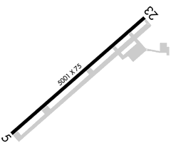
Runway 5
Latitude: 36-21.881602N
Longitude: 092-28.631408W
Elevation: 928.0 ft.
Traffic Pattern: left
Runway Heading: 049 magnetic, 052 true
Markings: non-precision, in good condition
Visual Slope Indicator: 4-light PAPI on right (3.00 degrees glide path)
Runway End Identifier Lights: Yes
Touchdown Point: yes, no lights
Instrument Approach: ILS/DME, RNAV
Runway 23
Latitude: 36-22.391467N
Longitude: 092-27.830908W
Elevation: 911.7 ft.
Traffic Pattern: left
Runway Heading: 229 magnetic, 232 true
Markings: non-precision, in good condition
Visual Slope Indicator: 2-light PAPI on left (4.00 degrees glide path)
Runway End Identifier Lights: Yes
Touchdown Point: yes, no lights
Instrument Approach: RNAV
Dimensions: 5000 x 75 ft. / 1524 x 23 m
Surface: asphalt, in good condition
Weight bearing capacity: Single wheel: 17.0
Runway edge lights: medium intensity